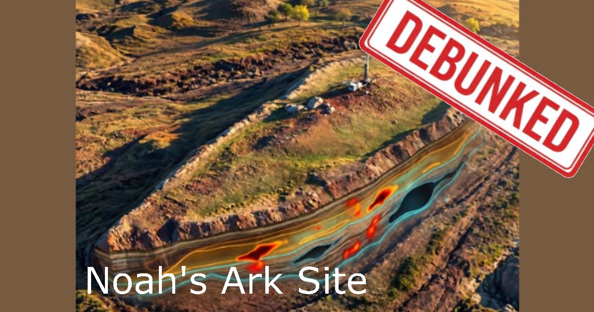
The Durupınar formation lies in the Doğubayazıt–Tendürek region of eastern Turkey, a landscape shaped by volcanism, folding, faulting, landslides, and erosion. The site itself is best explained as a doubly plunging syncline: folded sedimentary layers that close at both ends and were later exposed by erosion, naturally producing an elongated, boat-like outline.
When compared to the surrounding rock, it is no different in form or structure. Even the lens shape is similarly found in the surrounding geography.
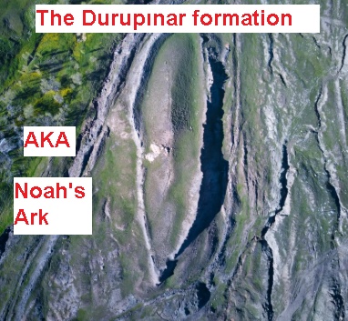
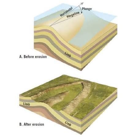
Similar lens-shaped and boat-like formations are common in the surrounding terrain because the same folded rock layers and erosional processes repeat across the region. When resistant beds remain while softer material erodes away, pointed oval forms can appear. Durupınar is therefore not a unique structure, but one example of a broader geological pattern visible throughout the area.
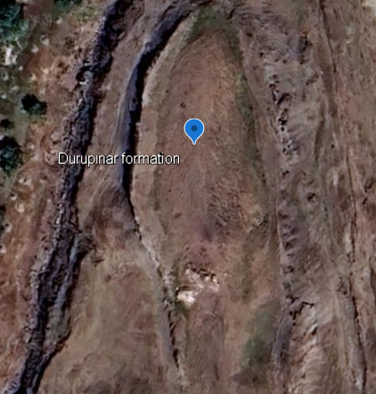
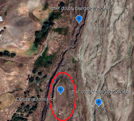
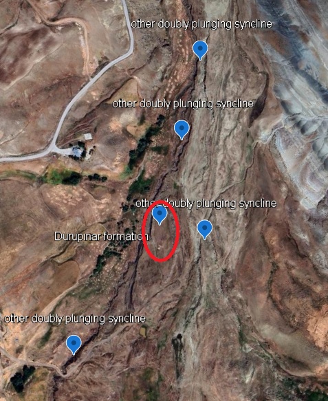
View the Durupınar formation and surrounding geology yourself:
https://earth.google.com/earth/d/1FUAoGQO_-fC2971i2rL6emdne_j945Ps?usp=sharing
The latest claims about Durupınar are being promoted heavily by Noah’s Ark Scans, an advocacy organization rather than an established scientific institution. Its founder, Andrew Jones, does not list professional qualifications in geology, archaeology, or another relevant scientific discipline, and the organization has never published a peer-reviewed scientific paper.
The Durupınar formation is not an unexplored mystery. Geologists and other investigators have examined the site repeatedly for decades. Geological studies have identified its supposed “walls” as naturally occurring sedimentary layers and mineral concentrations exactly similiar to the surrounding rock layers of the area.
There is no evidence that this unique geological lens shape is anything more than naturally occuring doubly plunging syncline shaped by well understood ordinary geological processes.
After decades of investigation, Durupınar has still produced no 4,000-year-old worked timber, no gopher wood, no constructed hull, no wooden joints, no ancient fasteners, and no evidence of any man-made structure of any sort. By contrast, ground-penetrating radar anomalies and traces of organic material are entirely compatible with the site’s geology. In a doubly plunging syncline that has been uplifted, fractured, exposed, eroded, buried, and reworked by sediment movement, subsurface contrasts, layered boundaries, moisture differences, mineral concentrations, and buried organic material are exactly the kinds of features that should be expected.
None of those findings identifies a ship. Radar detects changes in underground materials, not “rooms” or “decks,” and organic material can come from soils, plants, roots, sediments, or other natural sources. To demonstrate an ancient vessel, investigators would need unmistakably artificial evidence: worked wood in structural context, joined timbers, fasteners, tools, construction patterns, or datable remains clearly belonging to a manufactured hull. That evidence has never been produced at Durupınar because it simply does not exist.
Scientific Evaluation of the Durupınar Formation
The Durupınar formation has been investigated repeatedly since its identification in aerial photographs in 1959. The relevant geological literature has not established that the structure is an archaeological vessel. Instead, published studies have explained its morphology through natural geological processes.
1960 — Initial Field Investigation
An expedition organized after the 1959 aerial photographs examined the formation in 1960. The investigators found no identifiable archaeological remains and concluded that the site did not provide evidence of a constructed vessel. Importantly, the expedition did not include a geologist, so this was primarily an initial archaeological reconnaissance rather than a detailed geological investigation.
1976–1981 — Early Geological Assessments
Geologist Clifford Burdick and archaeologist William H. Shea discussed the formation in creationist scientific literature during the 1970s and early 1980s. Burdick interpreted the structure geologically rather than as an obvious archaeological hull, describing it in terms of natural deformation or uplift within the surrounding volcanic and sedimentary environment. Shea’s 1981 review likewise acknowledged that the formation presented primarily a geological problem and noted the absence of archaeological evidence from the original investigation.
1980s–Early 1990s — Geophysical and Core Investigations
During the renewed investigations associated with Ron Wyatt, David Fasold, John Baumgardner and others, the site was examined using metal detection, ground-penetrating radar, seismic methods, magnetometry and drilling.
Some investigators initially interpreted anomalies as evidence of internal structure. Subsequent geological investigations, however, found that the subsurface features could be accounted for by natural rock layers and geological discontinuities. Core drilling reportedly encountered natural rock stratigraphy rather than artificial structural material.
1996 — Collins and Fasold
The most important published geological critique is:
Lorence G. Collins and David F. Fasold, “Bogus ‘Noah’s Ark’ from Turkey Exposed as a Common Geologic Structure,” Journal of Geoscience Education 44, no. 4 (1996): 439–444.
Collins and Fasold concluded that Durupınar was a natural geological structure. They interpreted its geometry in terms of steeply inclined sedimentary strata and a doubly plunging synclinal configuration.
They also examined several alleged archaeological materials. Purported iron fittings were identified with naturally occurring iron-rich minerals, while material described as petrified wood was identified as geological rather than botanical. The authors likewise rejected the claim that nearby perforated stones demonstrated the presence of ancient ship anchors.
The significance of Fasold’s participation is considerable because he had previously been one of the principal advocates of the Durupınar-Ark identification.
2007 — Murat Avcı
A second important geological interpretation was published by Turkish engineering geologist Murat Avcı:
Murat Avcı, “‘Noah’s Ark’: Its Relationship to the Telçeker Earthflow, Mount Ararat, Eastern Turkey,” Bulletin of Engineering Geology and the Environment 66 (2007): 377–380.
Avcı interpreted the ship-shaped formation as a large displaced block of Miocene limestone associated with the Telçeker earthflow. Its present morphology was explained through mass movement, erosion, abrasion and dissolution rather than artificial construction.
This differs in detail from the Collins-Fasold interpretation but reaches the same fundamental conclusion: the formation can be explained geologically without invoking a buried ship.
2016 — Collins Reassessment
Geologist Lorence Collins revisited the Durupınar evidence in:
Lorence G. Collins, “Noah’s Ark near Dogubayazit, Turkey?” Perspectives on Science and Christian Faith 68, no. 4 (2016): 218–228.
Collins reviewed the site’s geology, mineralogy and alleged artifacts in greater detail. He again concluded that the supposed structural remains—including alleged iron fittings and petrified wood—were naturally occurring geological materials and that erosion and mass movement adequately explained the site’s morphology.
Summary of Geological Findings
Across several decades, different investigators have proposed somewhat different mechanisms for the exact development of the Durupınar formation. These include folding of sedimentary strata, landslide displacement, earthflow processes, differential erosion and dissolution.
That scientific disagreement concerns how the natural formation developed, not whether a manufactured wooden hull has been demonstrated.
No published geological investigation has established diagnostic shipbuilding features such as worked structural timber, joinery, manufactured fasteners, hull architecture or archaeological material demonstrably belonging to an ancient vessel.
The principal published geological studies instead identify Durupınar as a naturally produced geological formation.
Sources
Collins, Lorence G., and David F. Fasold. “Bogus ‘Noah’s Ark’ from Turkey Exposed as a Common Geologic Structure.” Journal of Geoscience Education 44, no. 4 (1996): 439–444.
Avcı, Murat. “‘Noah’s Ark’: Its Relationship to the Telçeker Earthflow, Mount Ararat, Eastern Turkey.” Bulletin of Engineering Geology and the Environment 66 (2007): 377–380.
Collins, Lorence G. “Noah’s Ark near Dogubayazit, Turkey?” Perspectives on Science and Christian Faith 68, no. 4 (2016): 218–228.
Shea, William H. “A Review of Recent Data from the Region of the Ark-Shaped Formation in the Tendurek Mountains of Eastern Turkey.” Origins 8, no. 2 (1981): 77–95.
Burdick, Clifford L., and related discussion in William H. Shea, “The Elliptical Formation in the Tendurek Mountains,” Creation Research Society Quarterly (1976).